

Project Title
River Development Gail – an integrative Natura 2000 Model
Project Area:
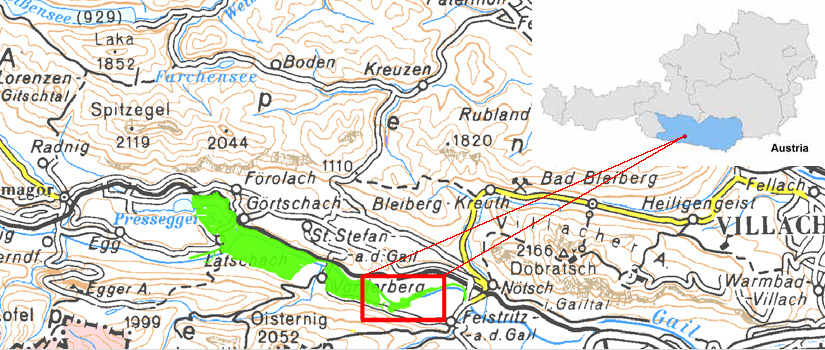
The project area comprises the Gail and its surroundings in the middle section of the Gail valley (Carinthia, Austria). It is part of the European Protected/Natura 2000 Area Görtschacher Moos-Obermoos (Figure 1), which became a Natura 2000 Area in 1998 and has been a European Protected Area since 2011. It includes the siltation area of the Pressegger Lake, the floodplains of the Gail and the Gail itself. Numerous protected and endangered species of animals and plants live in this wetland complex, one of the largest in Carinthia.

Figure 1: The European Protected Area Görtschacher Moos-Obermoos (green). Framed in red: The LIFE Project area.
Project Objectives:
• Exemplary renaturation of the Gail under consideration of flood protection
In its middle reaches, the Gail carries much fine sediment (mud and silt). These are deposited on the berms and narrow the discharge profile. If flood protection is to be maintained, the deposits have to be removed repeatedly as part of laborious maintenance work. Furthermore, the river exhibits a lack of natural structures within the dams and is ecologically impoverished.
The aim of the LIFE Project was to recreate characteristic habitats of the river type and to allow morphological processes, but also at the same time to maintain flood protection for downstream settlement areas and to minimize future maintenance work. In order to achieve this, possible solutions for the restructuring of the Gail were tested on three pilot stretches within the dams. The results of the trials are supposed to serve as the basis for further restructuring measures at the Gail and other rivers with similar problem situations.
• Qualitative und quantitative amelioration of habitats specific to riparian forests
Another aim of the LIFE Project was to improve river-specific habitats in the areas surrounding the Gail both qualitatively and quantitatively. A side channel as well as several bodies of standing water were to be created and old oxbow lakes restored. Through the purchase of land, intensively used agricultural areas were to be transformed into low-intensity wet meadows and riparian forest for river-specific habitats. These measures were also to improve the habitat connectivity between the patches of riparian forest.
• Exchange of experience and visitor information
The LIFE Project at the Gail was to be intensively communicated to the local population as well as to experts from the areas of conservation and flood protection.
Measures and Results:
After being officially launched on January 1st 2010, the project ended on December 31st 2014, as planned. In the five years of the project a broad set of measures was implemented:
• Restructuring of the Gail on three pilot stretches (total length: ca. 2 km; Habitats Directive, Annex I Type 3220: 8.7 ha);
• Creation of a side channel system, “Small Gail”, with a length of 2.5 km (Habitats Directive, Annex I Type 3260: 1.1 ha);
• Creation of 4 bodies of standing water (Habitats Directive, Annex I Type 3150: additional 2.6 ha);
• Revitalisation measures at three existing oxbow lakes (Habitats Directive, Annex I Type 3150: additional 0.4 ha);
• Purchase of 7.93 ha intensively used agricultural land for the creation of riparian water bodies, riparian forests and low-intensity managed land,
valuable from the point of view of conservation (Habitats Directive, Annex I Type 91E0: medium-term 5.4 ha, 6210: medium-term 2.5 ha;
6510/6410: medium-term 7.5 ha);
• Species conservation measures: stocking with ca. 1000 large mussels as well as ca. 5300 Bitterlings (Rhodeus amarus); Initial planting of
ca. 550 cuttings, 365 logs and 100 living root stalks;
• Creation of visitor facilities: viewpoint hill with information on LIFE, circular trail, water experience and bicycle path resting place at the
Vorderberger bridge, horse resting place, LIFE signposting;
• Public relations: design of a logo, homepage, poster exhibition, folder, latent image postcard, LIFE information boards, lay report, action days
(groundbreaking ceremony, 2 school action days, closing ceremony), 5 excursions;
• Networking: Exchange of experience with experts (South Tyrol, Italy, Serbia, Slovenia, LIFE Mur, LIFE Enns, LIFE Lavant);
• Monitoring: before/after study of the impacts of the project seen from the areas of study of fish, birds, ground beetles and other invertebrates,
amphibians, habitats and river morphology;
The total cost of the project measures was ca. 2.54 million Euros, ca. 1.27 million of which came from the LIFE Nature Fund of the EU, the Federal Water Engineering Administration in Carinthia bore more than half of the remaining cost with 0.98 million Euros, the rest was financed by the State of Carinthia.
Project Organisation and Partners
The management of the project and the implementation of the measures, as well as the public relations, were the responsibility of the Carinthian state government department 8 (AKL 8) - Competence Centre for Environment, Water and Nature Conservation (subdivisions Protective Water Management and Water Management Hermagor, designated as AKL 18 Water Management until 2011). The AKL 8 subdivision Nature Conservation and National Park Law (until 2011: AKL 20, subdivision Nature Conservation) was responsible for specialized support in the area of nature conservation, especially the species protection measures and the monitoring. The LIFE Project was coordinated by REVITAL Integrative Naturraumplanung GmbH.

